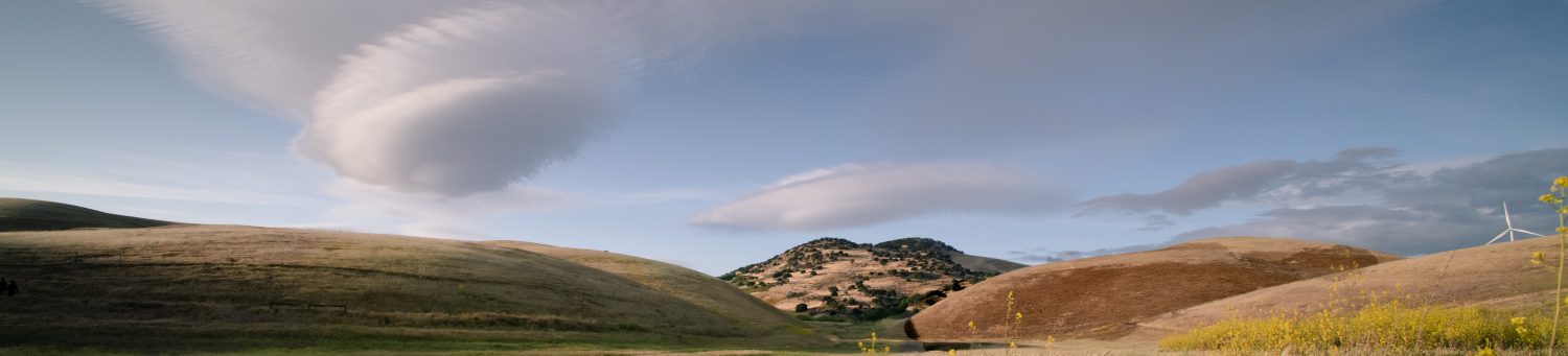

Outside of King City, the Coalinga Road is full of potholes, recently filled with asphalt. I pass a few ranches and rolling knolls and it’s slow going, but beautiful, and eventually I come to Oak Flat campground at the entrance to Clear Creek – an open wilderness managed by the BLM. It’s almost dark and a moonless night and the solar eclipse was two days ago and the sky is arid and alive with electricity. What I’m after is difficult to explain, other than to say I’m holding onto the tail of something that has influenced me to such an extent that I cannot let go. Out here, along the San Benito River, my own life is intermingled with history. I’m on the Mountain Path, la Vereda del Monte, which for me is everywhere and in all things, and as I pass through this land, it becomes my land, the same land as it has always been, the same as it was for Joaquin Murrieta. Murrieta needs no introduction here, other than to say, the fugitive horseman who drove herd from Marsh Creek, past Livermore, up the Tesla grade, through the San Antonio pass, and down the spine of this impassable range, still intrigues me. Every time I delve a little deeper, I find something about this misunderstood figure, every time I take it a little further, I find something about myself. The tale eclipses at Three Rocks, Murrieta’s notorious hideout, where, a century and half ago, his fortress of boulders outlined the mountain top, as it does today, as if flung there by giants. From there, he could look across the valley and see the last of the twelve Estaciones, where his crew of mesteñeros below, corralled the final drove of mustang to be herded to Sonora, Mexico.
At Oak Flat, the night is populated with a blanket of stars, and without a moon, they are endless. It is with caution that I walk through the padlocked gate and follow the grade upward, the creek rushing below, the air invigorating, with no other sound, not even a coyote howl. In the darkness my eyes strain to see the road ahead, as it winds into the serpentine wilderness and vanishes into the night – to follow it in a car in the daytime you need a permit from the BLM, a code to unlock the gate, and a day to drive the forty miles. But it is the only way to the rocks, as far as I know. Tonight, I will take in the air, even tomorrow, without a permit, I will go no further. What I am after in the morning is reconnaissance; another way in that will lead directly to the rocks, even a trail that I can walk over private land. Finding it has been challenging, I have looked on every map I can get my hands on and googled to extinction, and other than Latta’s reference to the trail he took, eighty years ago, I can find nothing. From Cantua Creek, one can see Three Rocks distinctly, only a few miles from the highway*, but covering the terrain with its steep arroyos, even if I were to jump fences and cross private land, would be more than foolish. So my only hope to get to the rocks, other than to drive the road I am standing on, for six hours, then hike four miles more, is to get lucky. (*Highway 5 at Derrick Road),
The morning is bright with a cloudless sky and after a cuppa’, boiled on the stove, I make my way on foot up the canyon again. A couple of years ago I drove this road and not too far in there was a washout, and in the daylight, I want to see if the road has been maintained. I come to it soon enough, a Caterpillar Tractor standing on top of a mound of dirt. And although it doesn’t guarantee the road is in good shape further on, it’s a positive sign. If I can’t find another way in, I’ll reserve a permit when I get back and drive it. I’m going to Google the navigation lady for Joaquin Rocks Lookout Trail as soon as I can get a signal, for now, it’s still early, and I make my way back to Oak Flat and pack my gear.
Coming to the highway, I cross the creek at the foot of the grade and pass the monument to Ray Eade. The flag is still flying, tattered and adrift in the breeze and I think of Vietnam as I pull onto Coalinga Road, and how I could have been him. Then I think of my father, a Marine, who served in Korea. I’m not holding back, I want to cry, but tears are hard to come by. Then the navigation lady on Google Maps is telling me that the ‘Lookout Trail’ is a few miles off and I head down the grade through the pass, stopping only once, when I drive into a glen, covered in shadow, and feel as if I’m being dragged into the earth by an old oak, basking in its glory. The hillsides are steeped in green, the water is flowing, with the windows rolled down, the croaking frogs bring a sound I have not heard in a long while, and with it, a swoon of memories. My earliest years were spent in a creek, a different tale all together, but it brings to mind how infrequent the sound of frogs is heard, and how there are fewer polliwogs than there used to be. In 500 meters, the google lady reminds me, is my destination, and as I prepare to pull off the road, I look in the rearview mirror, but nothing quite prepares me for this. It isn’t the gate I remembered at all, and the road in the distance, I am sure, I’d never laid eyes on.
An outcrop of rock with jagged peaks stands a couple of miles up the canyon, and the gate, with several padlocks, affronts private property, and at first glance, looks more like another road onto BLM land. I sit in the turnout and consider the predicament – this being my first fence jump since I was hit by a car on my bike a few months back – and I deliberate, how true is the path, and how real the obstacles? The decisive factor is the vaulted peaks, looming, just to my left.
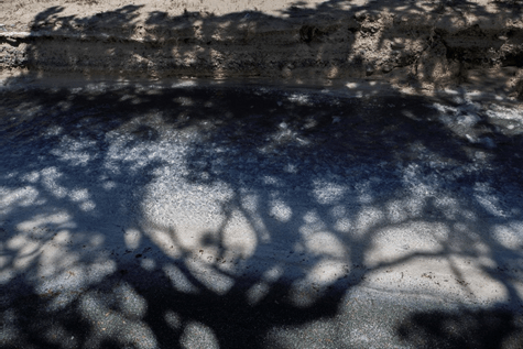
I always struggle with the idea of climbing a fence, and because I travel alone, make a small footprint, and take only pictures, I have no compunction, yet it is private land and comes with a risk. I hesitate, but only for a second, then I grab my bag and am up and over, then over the bluff in less than a minute. The creek on my left is rolling along at a clip and I’m stopped almost immediately where it cuts across the road., it’s only two feet deep but it’s twenty feet wide, with no visible place, up or down, to ford. I stand for a moment considering my next move; if I continue, my shoes will be soaked to the socks, not the best way to start off a hike, and then I’m starting to think, ‘maybe I should turn around, try and contact the owner.’ Then I look back over my shoulder in the distance, Like the Emerald City, a promontory that marks the gateway to where? I knew not, the odd color of the creek and the stark landscape had Murrieta all over it. ‘Even if it goes nowhere, there’s a picture in it’, I say to myself. So, with a new resolve, I take off my boots and walk across. After I put them on, a few hundred yards up, I see an outcrop of rocks, and the next thing you know, I’m on top of this boulder, as white as snow and the surface is sort of spongy like dried grass, only its white, like freeze dried snow, and I say to myself ‘WTF?’,
Then I dunk my head in the creek, which I later find out is called White Creek, and it snaps me around just enough to realize that this is magic, all around me, and just as I’m thinking to myself how fortunate I am to have taken this road, I see an ATM hugging the curve, down the hill like rain runoff, right for me. Instantly, I cast aside all future plans for adventure, at least for the day, and consider it’s either the rancher, or an employee, or maybe it was a ranger, barreling to the bottom of the grade, followed by a wisp of dust like a tail, in which case, I would have to talk my way out of a ticket. When next I look up, I can see it’s a woman in sunglasses and a windbreaker, maybe someone making the rounds, or it could be the law, they have women law enforcement in the BLM, either way, I was toast. When she pulled up, the first thing I said was, “I know I’m on private property and I apologize,” then I looked over, pointing to the spires etching the horizon and said, “To tell you the truth, I’m a bit of an adventurer, and I’m doing some research, looking for a trail that goes up to Joaquin Rocks, it’s called Las Tres Piedras.” I recited with a slight accent, “Have you heard of them?” At which point, you cracked a grin and said, “if you’re thinking about getting to the rocks this way, you’re out of your mind,” then looked me over, more like a curiosity, as if I would dare such a feat, starting out at noon, with a water bottle, and what, a camera? Yes, I was a photographer, I told her, but today the light wasn’t very good, and you said, “What, you don’t like the sunshine?” And I said, “ too much contrast.” and you said that you liked the cloudy days too, same as me, and I said, “I’m going to come back on a better day” and then you asked me if I wanted a ride down to the gate, informal enough, so I said that I would prefer to walk, “Do you mind?” Making sure to say it in a way like I was asking for permission, which I was. “Naw, I don’t mind,” you said, then you asked, “What do you want to go to the rocks for, anyway?” and before I could answer, you said, “You know the best way to do it is to contact the BLM, get a permit, you can drive all the way back in there, right along the ridge, until you come to the end of the road, and a turnout, where you can camp. From there, it’s only a three or four mile hike in.” I listened attentively, in part because I like the story, in part because I was wondering just who I was talking to. So I asked her straight up and she said that she was the daughter of the rancher who started the ranch up here, nodding up the hill, and then I asked her if she was born here, and you said ‘yep’ and then I asked if you lived here your whole life, and you nodded, and I said “went off to university, right?” and you said, “oh yeah,” with a wryness, “you live on a ranch, you have to pretty much help support it, I taught high school for god knows how long.” Frank Latta taught high school, and then I asked her, out of the blue, if she ever heard of him. And even through her sunglasses, I could see her eyes widen and the next thing I know, she’s telling me that the photograph in Frank Latta’s book, of him riding horseback with his family to Joaquin’s Rocks, in 1935 – the very book I’ve been studying for three years, the very trail I am trying to find – is her grandfather standing next to her grandmother – who owned the land I am now trespassing on. Mr. and Mrs. Birdwell of Los Gatos Canyon gave Latta permission to ride the trail, and picnic at Joaquin’s favorite camping spot where, according to Latta, hand gestures were exchanged from Ojo de Aguila (Eagle Eye, aka: Juan Lopez), perched on the promontory, and using a spy glass to see onto the valley floor at Cantua Creek, where the twelfth and final Estacione was located before the herd was driven directly south. (After Murrieta and his crew had gathered the desired 300 head, this next leg, all the way to Sonora, was run by a different crew chief, Teodoro Valenzuela.)
At this point in our conversation, I asked if the offer for a ride was still on, and you said “of course” and I climbed in, expressing my gratitude and said, “It will keep me from having to take off my shoes at the creek,” and you laughed. Then I asked, how come the creek was so white, and you said, “magnesium,” and then you told me that you used to drink it all the time as kids, every time you went swimming in the summer. “Tastes a little funny, but it doesn’t hurt you, keeps your teeth white,” you said with a smile. On the rest of the way down you told me about Latta, and a friend of yours who just wrote a book on Murrieta and was busy writing another one on Loco Marianna, who claimed to be Murrieta’s mistress. And then I told her a little about my project, and we swapped emails, and when we came to the gate, I dipped through, the way I came, looking back with a wave. Pulling onto Los Gatos Creek, I tried to process the tail of the eclipse that I was holding onto – way outside the path of totality, I concluded, there is another path. Joaquin Murrieta gave it a name.
